Situating Tool
Remember those days of slogging through textbooks, memorizing facts that felt like they existed in a vacuum? Thankfully, education technology is evolving, and with it, our approach to learning. One concept that has me buzzing is situating tools.
These aren't your average educational apps. Imagine VR field trips to the pyramids or simulations that put you in the heart of a bustling marketplace. Situating tools place learners directly within an environment, allowing them to experience the context and events firsthand.
This shift from passive learning to active engagement is a game-changer. Suddenly, history isn't just dates and names; it's the sights, sounds, and maybe even the smells of a bygone era. Science isn't just textbook diagrams; it's manipulating variables and observing the cause and effect in real-time.
Think about the possibilities! Educational games that encourage collaboration, 3D modeling that brings complex concepts to life – situating tools have the potential to spark creativity and visualization skills like never before.
But are virtual experiences a replacement for real-world learning? Not quite. Dissecting a frog in a lab or navigating the social dynamics of a group project are experiences that might be difficult to perfectly replicate digitally.
The ideal approach seems to be a blend. Imagine a classroom that utilizes situating tools alongside traditional methods. Students could explore the Great Barrier Reef virtually, then delve deeper with a lecture on marine biology. The possibilities for a more comprehensive and engaging learning experience are endless.
As technology continues to develop, situating tools are poised to revolutionize education. They have the power to transform learning from rote memorization to a truly immersive and transformative experience. I, for one, am excited to see where this future takes us!
Some of the tools we explored are Google earth, Google map and GeoGebra.
1. Google earth: Google Earth, a virtual globe that puts the entire world at your fingertips. It's more than just a digital map – it allows you to zoom in and out, tilt the perspective, and even explore 3D terrain and buildings in many cities.

Imagine virtually soaring over the majestic peaks of the Himalayas or diving down to street level in bustling Tokyo. Google Earth integrates satellite imagery and Street View, allowing you to explore a location from a variety of angles. It's a fantastic tool for geographers, travelers, or anyone curious to virtually journey across the globe.
2. Google Map: it's so much more than just getting directions from point A to point B. Sure, it helps you navigate traffic jams and find the quickest route, but it also acts as a digital explorer's toolkit.
Imagine being able to virtually wander the cobblestone streets of Rome or discover hidden hiking trails in Yosemite National Park – all from your computer screen. Google Maps integrates street view, allowing you to explore a location at street level, as if you were walking down the sidewalk yourself.
For the history buffs, there's even a "Time Travel" feature (available in select locations) that lets you see historical imagery of a place. It's a fascinating way to see how landscapes and cities have transformed over time.
Google Maps goes beyond sightseeing too. You can search for specific businesses, check real-time traffic conditions, and even plan your commute with public transportation options. It's a powerful tool for anyone looking to navigate the world, both literally and virtually.
3. GeoGebra is a free, interactive software that transforms your computer into a dynamic math playground. It combines the power of geometry, algebra, calculus, and even statistics into one user-friendly program. Imagine a world where you can not only graph equations and construct shapes, but also see them come alive and manipulate them in real-time. Sounds pretty cool, right?
The beauty of GeoGebra lies in its accessibility. It's completely free and available for desktops, tablets, web browsers, and even has mobile apps! This makes it a perfect tool for students of all ages, from curious elementary schoolers to university math whizzes.
Today in class, we used GeoGebra to conquer the equilateral triangle – that elusive shape with all sides and angles equal. Here's how we did it in a few clicks:
1. Building the Base: We started by defining a point using the handy "Point" tool. This became the first vertex of our triangle. GeoGebra even named it for us (think fancy letter A).
2. Creating the Canvas: Next, we used the "Circle" tool to create a circle centered at our point A. Remember, we want an equilateral triangle, so we played with the radius to get the desired size. GeoGebra even displayed the circle's equation for the algebra lovers out there!
3. Finding the Perfect Spot: Here's the clever part. We used the circle tool again, but this time we clicked directly on the circle itself. GeoGebra, like a math magician, found the perfect intersection points, creating two new points on the circle's edge – like magic!
4. Connecting the Dots: Finally, we used the "Line" tool to connect our three points (A, B, and the newly created point C). Voila! GeoGebra instantly transformed these lines into a perfect equilateral triangle.
5. A Touch of Polish: To clean things up, we used the "Move" tool to hide the circles and labels that helped us construct the triangle. Now, we were left with a pristine equilateral triangle, ready for further exploration.
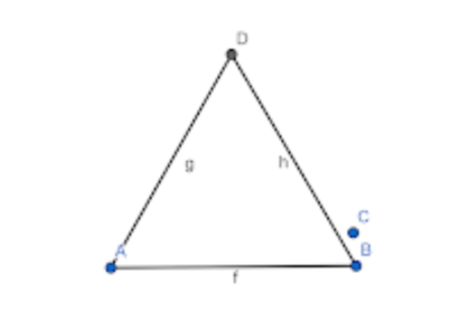
Here's how my final product looks after all the process:
Comments
Post a Comment